Surveying Articles - Land Surveyors United - Surveying Education Community
Enclosure: https://landsurveyorsunited.com/articles/the-hidden-role-of-surveyors-in-earth-day-s-mission
Enclosure: https://landsurveyorsunited.com/articles/the-coming-liability-crisis-who-gets-sued-when-ai-mapping-gets-it
Enclosure: https://landsurveyorsunited.com/articles/the-generational-knowledge-gap-where-are-the-next-surveyors
Enclosure: https://landsurveyorsunited.com/articles/surveying-s-crossroads-a-constructive-counterpoint-to-the-nationa
Enclosure: https://landsurveyorsunited.com/articles/surveyors-the-last-defenders-of-ground-truth-in-a-virtual-world
Enclosure: https://landsurveyorsunited.com/articles/how-to-build-the-future-of-surveying-through-education
Enclosure: https://landsurveyorsunited.com/articles/why-noaa-is-the-most-important-agency-you-ve-never-thought-about
Land Surveyor Forum - Land Surveyors United - Surveying Education Community
Hello everyone, I am facing one issue with the...
Enclosure: https://landsurveyorsunited.com/forum/topics/gnss-level-against-digital-level
With Remote ID going into effect on September 16th, it has never been more important to conduct public drone operations responsibly. Part 107 pilots must understand...
Enclosure: https://landsurveyorsunited.com/forum/topics/best-practices-public-drone-operations
Hi everyone I am looking for land surveying programs for Casio fx 4500 p . If anyone has them I will appreciate posting them for everyone to use. Thank you so much. Sami Barkho
Enclosure: https://landsurveyorsunited.com/forum/topics/casio-fx-4500p-programs
Please is their anyone who can assist me on how to add codes to my...
Enclosure: https://landsurveyorsunited.com/forum/topics/code-with-leica-total-station
Good day everyone. I recently started working for a small firm after a 6 1/2 year hiatus from surveying and I am currently doing things the old fashioned way by turning angles with an old Sokkia Set4 with nothing more than a field book as a data collector. Needless...
Enclosure: https://landsurveyorsunited.com/forum/topics/help-with-communication-between-a-leica-tcrp1203-and-an-allegrocx
Hi everyone, I'm Ziyad and I'm reletively new to...
Enclosure: https://landsurveyorsunited.com/forum/topics/hello-and-question-about-lsit-in-wyoming
Land Surveying Video Guides - Land Surveyors United - Surveying Education Community
Enclosure: https://landsurveyorsunited.com/video/how-to-pace-in-land-surveying
Enclosure: https://landsurveyorsunited.com/video/fundamentals-of-surveying-playlist-17-video-tutorials
Enclosure: https://landsurveyorsunited.com/video/episode-197-russell-white
Enclosure: https://landsurveyorsunited.com/video/introduction-to-lesson-materials-and-elements-of-right-triangles
Enclosure: https://landsurveyorsunited.com/video/about-land-surveying-boundary-surveying-basics
Levelling Numerical #2 | Height of Instrument Method| 3rd Semester Diploma in Geomatics Engineering|
Enclosure: https://landsurveyorsunited.com/video/levelling-numerical-2-height-of-instrument-method-3rd-semester-di
🗓️ Land Surveyor Events & Conferences - Land Surveyors United - Surveying Education Community
Enclosure: https://landsurveyorsunited.com/events/fsms-70th-annual-conference
Surveyor Apps and Community Updates - Land Surveyors United - Surveying Education Community
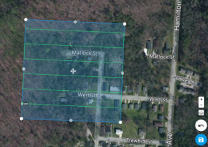
 https://www.aerotas.com/blog/how-to-unlock-a-dji-geo-zone DJI’s Geospatial Environment Online (GEO) delineates where it is safe to fly, where flight may raise concerns,...
Enclosure: https://landsurveyorsunited.com/notes/unlocking-dji-geo-fencing
Enclosure: https://landsurveyorsunited.com/notes/major-upgrade-to-land-surveyor-dictionary-app-new-features
Enclosure: https://landsurveyorsunited.com/notes/goodbye-2021-and-hello-new-year-2022
Enclosure: https://landsurveyorsunited.com/notes/gis-surveyor-app-for-surveyors-and-gis-professionals
Enclosure: https://landsurveyorsunited.com/notes/land-surveyor-sound-off-app-is-the-prelude-to-savvy-surveyors-sho
Enclosure: https://landsurveyorsunited.com/notes/latest-disciplinary-actions-of-the-texas-board-of-professional-en
Land Surveyor Blogs - Land Surveyors United - Surveying Education Community
Enclosure: https://landsurveyorsunited.com/profiles/blog/list/mapping-monday-colton-s-illustrated-and-embellished-steel-plate-m
Enclosure: https://landsurveyorsunited.com/profiles/blog/list/topic-thunder-thursday-green-surveying
Enclosure: https://landsurveyorsunited.com/profiles/blog/list/mapping-monday-popple-s-map-of-the-british-empire-in-america
Enclosure: https://landsurveyorsunited.com/profiles/blog/list/tools-for-tuesday-the-tilting-level
Enclosure: https://landsurveyorsunited.com/profiles/blog/list/wisdom-wednesday-this-week-in-history-the-partitioning-of-korea
Enclosure: https://landsurveyorsunited.com/profiles/blog/list/tools-for-tuesday-the-echo-sounder
Latest Activity on Land Surveyors United - Global Surveying Community
The surveyor hub for California Land Surveyors was featured
The surveyor hub for Alaska Land Surveyors was featured
The surveyor hub for Alabama Land Surveyors was featured
The surveyor hub for Arkansas Land Surveyors was featured
The surveyor hub for Alaska Land Surveyors was featured
The surveyor hub for Arizona Land Surveyors was featured
Land Surveyors Dictionary - Land Surveyors United - Surveying Education Community
Enclosure: https://landsurveyorsunited.com/almanac/double-corner-rls-pls-rpls-plss
Enclosure: https://landsurveyorsunited.com/almanac/construction-survey
Enclosure: https://landsurveyorsunited.com/almanac/affidavit-of-merit
Enclosure: https://landsurveyorsunited.com/almanac/magnetic-declination
Enclosure: https://landsurveyorsunited.com/almanac/boundary-dispute
 Land surveyors have always produced drawings that...
Enclosure: https://landsurveyorsunited.com/almanac/drone-aerial-mapping
📸 Land Surveying Photos - Land Surveyors United - Surveying Education Community
Enclosure: https://landsurveyorsunited.com/photo/299648859-6085742914787302-2449322097838138976-n
Enclosure: https://landsurveyorsunited.com/photo/217563555-4817394548288818-6325861280813753474-n